
Qhapaq Ñan
An Andean road system of more than 30,000 km, developed over centuries and expanded to its greatest extent during the 15th-century Tawantinsuyu.

A road is evidence under your feet
The famous trek is one surviving passage through a much larger Andean system of roads, state power, sacred geography and local continuity.
The Incas did not build one road officially called “the Inca Trail.”
UNESCO describes the Qhapaq Ñan as a network exceeding 30,000 km, created over centuries and partly based on pre-Inca infrastructure. The route toward Machu Picchu belongs to that historical world, but today's Classic trek is a modern itinerary through the protected sanctuary.
That distinction prevents the functions of an entire empire-wide system from being assigned automatically to every stone on the Machu Picchu approach.
See what the evidence supportsThree related—not identical—things
Clear names make the history easier to understand and avoid conflating two separate UNESCO World Heritage properties.
An Andean road system of more than 30,000 km, developed over centuries and expanded to its greatest extent during the 15th-century Tawantinsuyu.
An extensive network of roads and trails connecting archaeological, agricultural and water-management features in the Machu Picchu landscape.
A regulated trekking itinerary through part of that historic landscape—not the name of the empire's entire road network.
Built over time—not in one year
Long-distance Andean routes existed before the Inca Empire. During Tawantinsuyu's rapid expansion, the state incorporated, extended and organized earlier infrastructure into a network linking Cusco with production, administration and worship across extreme terrain.
No surviving record gives one construction date for every section of the modern trek. It is safer to connect the Machu Picchu landscape to the 15th-century height of Inca power than to invent a groundbreaking day or single architect.
Maximum expansion of the wider Qhapaq Ñan during consolidation of Tawantinsuyu.
Purpose depends on scale
Inca political authority, movement, economy and religion were connected. A modern either/or answer oversimplifies that world.
Across the wider Qhapaq Ñan, roads supported state communication, administration, production, storage, military movement and travel between centers.
The Machu Picchu sanctuary contains roads, subsidiary centers, terraces and irrigation works integrated with difficult terrain.
Architecture, water features, gateways and the sequence toward Machu Picchu support interpretations that ritual experience mattered on this particular approach.
No surviving Inca-written statement proves that the entire route was constructed in one project for only pilgrims, armies or trade.
Engineering was social organization
Road builders changed paving, width, walls and steps according to slope, soil, water and climate.
Paved surfaces, stairways and retaining structures made steep mountain movement durable on foot.
Drainage and erosion control were structural requirements on the wet eastern Andean slopes.
The system served walkers and pack llamas rather than wheeled carts, shaping its direct stairs and mountain geometry.
Across the wider network, bridges, storage, lodging and messenger stations made roads function as a system.
Mit'a labor obligations and local technical knowledge supported construction and maintenance at imperial scale.
The sites are part of the route's argument
The road connects constructed places across changing elevations. Together they show that travelers entered an organized cultural landscape rather than crossing empty wilderness.
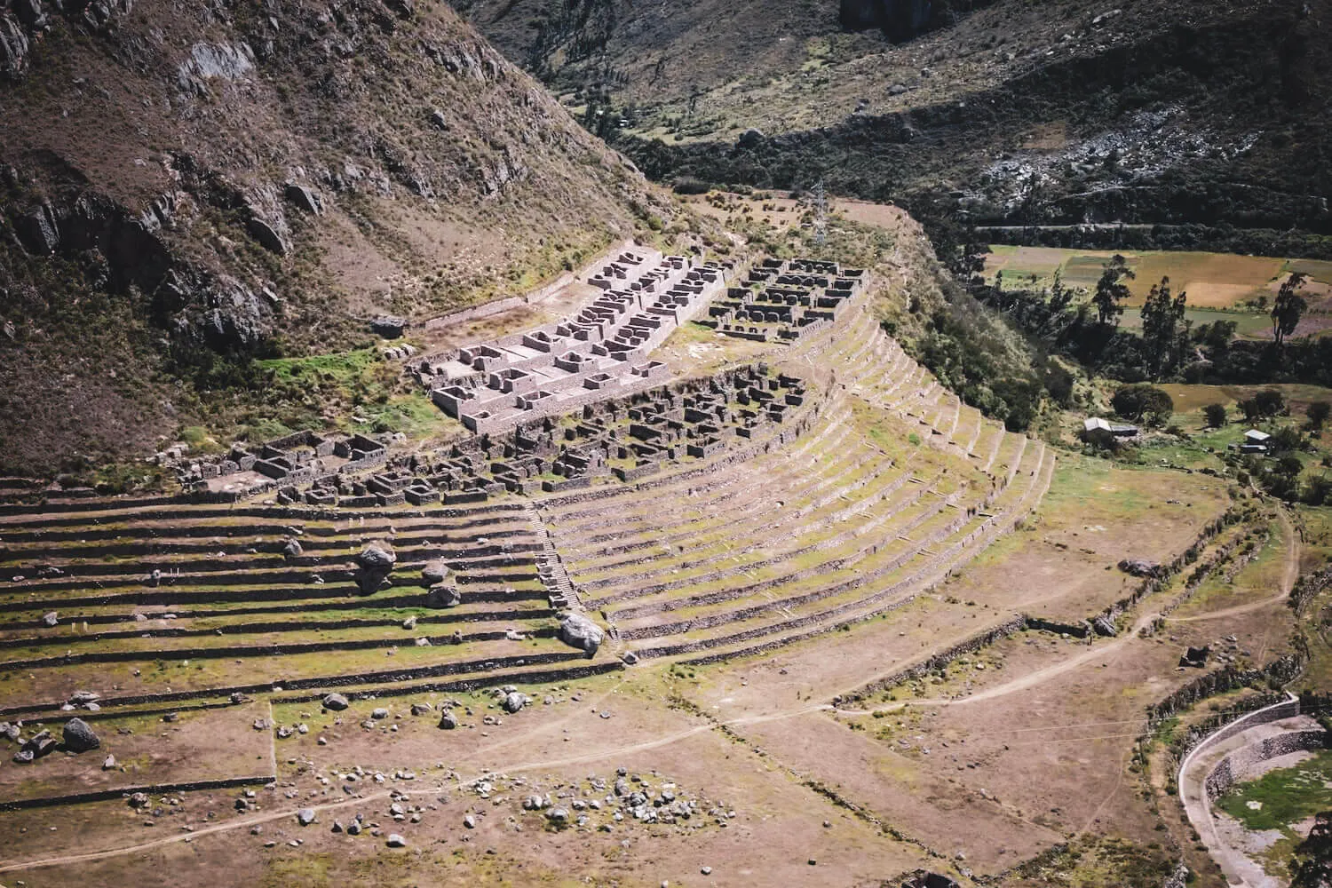
Settlement, agricultural terraces and valley organization appear near the beginning of the Classic journey.
A compact circular structure shows that the high route connected deliberately built places.
Architecture occupies a steep ridge where movement and topography are inseparable.
Terraces, buildings and water features demonstrate construction continuing at high elevation.
Terraces, fountains and architecture make it central to ceremonial-route interpretations.
A constructed gateway organizes the final approach and view toward Machu Picchu.
1911 did not begin local knowledge
Hiram Bingham reached Machu Picchu on July 24, 1911, while investigating Inca sites. Yale's educational record identifies local resident Melchor Arteaga as the person who led him toward the ruins.
Bingham's expeditions documented, photographed and publicized Machu Picchu widely. But people lived in and knew the region before his arrival, and some of his early interpretations changed as archaeological research advanced.
Language checkA place can become newly visible to international academia without having been unknown to the people living around it.
Continuity and change
Dates mark changes in political scale, outside documentation and heritage protection—not moments when local relationship with the landscape simply began or ended.
Andean communities developed routes and infrastructure later incorporated into broader road systems.
The Qhapaq Ñan reached its maximum expansion as Tawantinsuyu consolidated across the Andes.
The city and surrounding engineered road landscape belong principally to the height of Inca power.
Spanish invasion dismantled the political system that organized imperial road functions; local use did not simply disappear.
Hiram Bingham reached Machu Picchu with local assistance and later publicized it internationally.
UNESCO inscribed the Historic Sanctuary of Machu Picchu as a mixed cultural and natural property.
UNESCO inscribed selected Qhapaq Ñan components across six countries as a separate serial cultural property.
The trail is at once archaeological infrastructure, a protected living landscape and a regulated visitor route.
An honest history labels uncertainty
Five corrections
Tourism narratives often prefer one builder, one purpose and one discoverer. The evidence describes a more interesting system.
No. The state incorporated earlier Andean infrastructure and knowledge while expanding and organizing the system at exceptional scale.
The modern trek is one visitor itinerary within a much larger and more complex road landscape.
Ceremonial use is a meaningful interpretation, but administration, political authority and sacred geography were not cleanly separated.
Local residents knew the site. His expeditions documented and brought it to much wider international attention.
The modern itinerary uses genuine historic road and archaeological sites, while camps, controls and visitor logistics are modern management layers.
Protection is part of the current chapter
Stone paving, stairs, retaining walls, water channels and buildings are the historical resource itself. Visitor controls, authorized access and conservation rules answer a modern problem: how people can experience the road without gradually erasing it.
Stay on designated paths, never climb ancient masonry or remove material, respect closures and ask guides to distinguish evidence from interpretation.
Understand regulated accessHistorical questions
Short answers preserve the distinction between the empire-wide network and the modern Machu Picchu trek.
The Machu Picchu road landscape is associated principally with 15th-century Inca expansion. The wider Qhapaq Ñan incorporated infrastructure and traditions that predated the Inca state.
No individual architect is known. Construction and maintenance relied on organized state labor obligations, local communities and specialist knowledge adapted to different Andean environments.
The wider network served communication, administration, production, movement and defense. The monumental Machu Picchu approach also supports ceremonial interpretations, but no evidence establishes one exclusive purpose for the entire route.
It belongs historically to the wider Andean road world associated with the Qhapaq Ñan. UNESCO's Historic Sanctuary of Machu Picchu and its 2014 Qhapaq Ñan serial property are separate listings, so the two should not be treated as identical boundaries.
Machu Picchu and major imperial expansion are commonly associated with Pachacuti's 15th-century period, but evidence does not show that one ruler personally designed or ordered every section used by modern hikers.
Possibly in important ways. The site sequence, water features, architecture and controlled approach support ritual interpretations. Presenting the entire trail as exclusively a pilgrimage road would go beyond the evidence.
Not as a place unknown to everyone. Local resident Melchor Arteaga helped guide Bingham to the site in 1911. Bingham's expeditions documented and publicized it for international audiences.
The integrated state system behind the roads collapsed and their political roles changed. Some routes continued in local use; others lost maintenance or importance under new colonial patterns.
It follows genuine Inca road and passes original archaeological sites, but the Classic Trail is a modern regulated itinerary through a larger historic network.
This page prioritizes official heritage records and museum scholarship. Claims about ceremonial purpose are labeled as interpretations rather than settled fact.
Terminology and archaeological interpretation can evolve. Corrections from qualified researchers and local knowledge holders are welcome.
Context changes every step
Then plan access in a way that respects the road you came to understand.