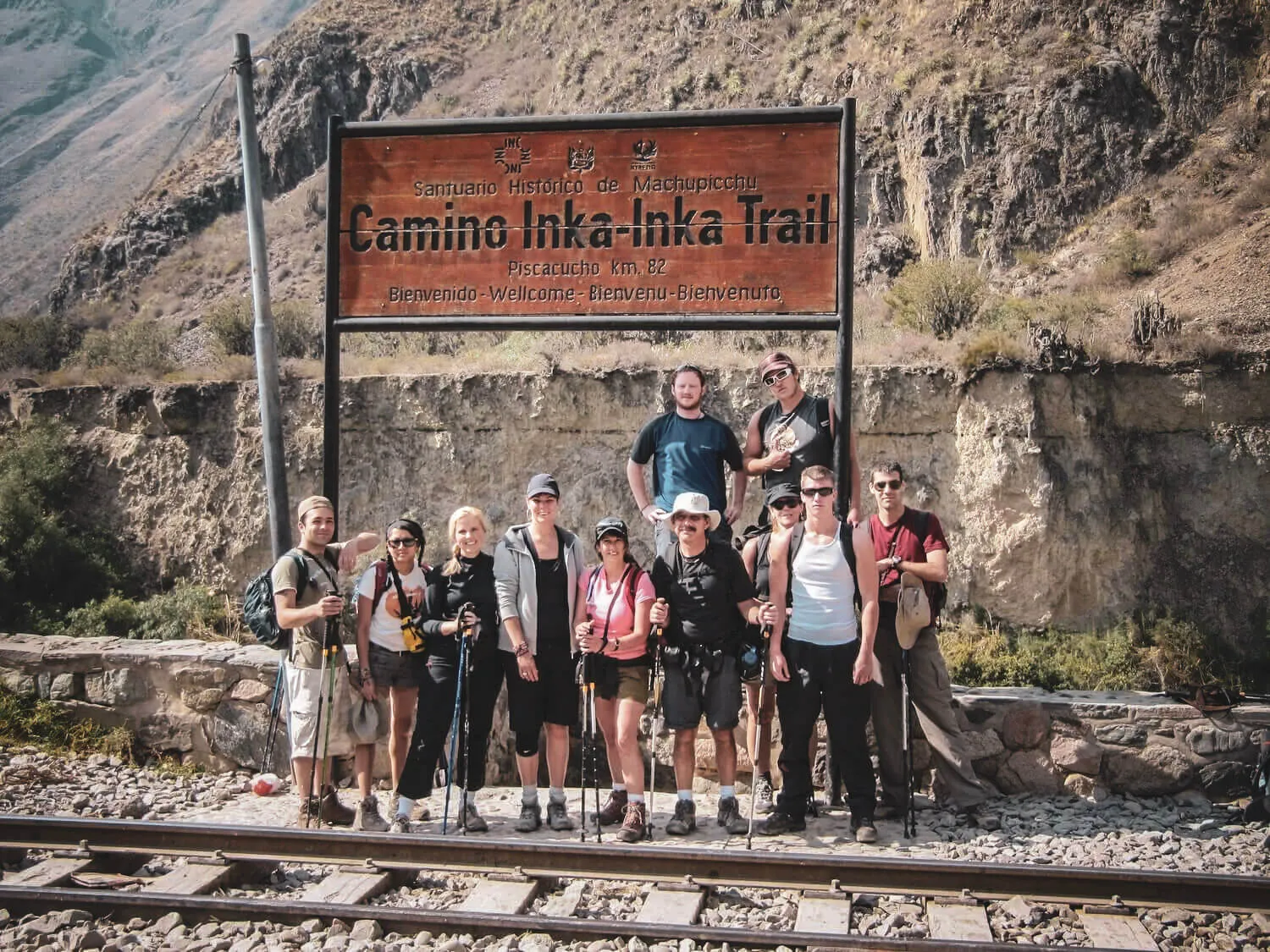
Hikers at the Piscacucho Km 82 starting sign for the Classic Inca Trail

From Piscacucho to Machu Picchu

Inca Trail Map: Route, Distance, and Where It Starts

The Classic route runs approximately 39 km / 24 mi from Km 82 to Inti Punku, the Sun Gate, before its final descent toward Machu Picchu.

By Luca Rodríguez · Local guide and writerReviewed August 5, 2026Cusco, Peru

The route crosses river valleys, high Andean passes, archaeological complexes and cloud forest before reaching Machu Picchu from above.

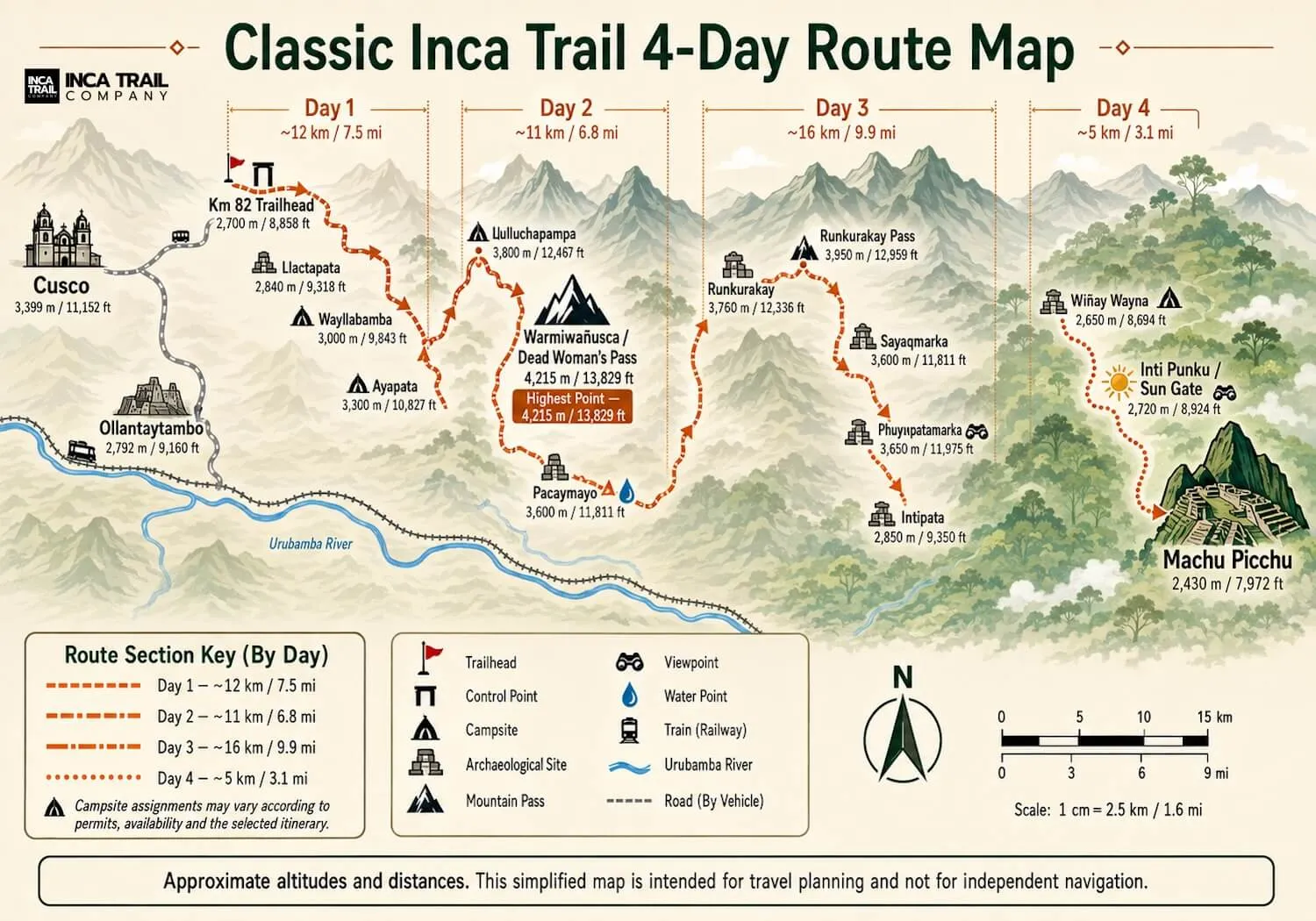
The map below shows the common Classic four-day geography. It is a planning reference, not an independent-navigation map; campsite assignments and operational sections can vary.

View the complete route map

Classic route overview

Km 82 to Inti Punku and Machu Picchu

The route generally moves east through the sanctuary: away from the Urubamba valley, over the high passes and back down through cloud forest toward the Sun Gate.

Classic Inca Trail route map from Km 82 through Dead Woman’s Pass, archaeological sites, Wiñay Wayna and the Sun Gate to Machu Picchu
Simplified Classic Inca Trail map. Distances, camps and altitudes are approximate and should not be used for independent navigation.
Km 82
Classic Inca Trail starting point at Piscacucho
Warmiwañusca
Dead Woman’s Pass and the route’s highest point
Wiñay Wayna
Last major archaeological complex before the Sun Gate
Inti Punku
Historic gateway and first elevated approach to Machu Picchu
Machu Picchu
Final destination after descending from the Sun Gate

Where it starts

Km 82 at Piscacucho

“Km 82” identifies the trailhead’s position along the railway corridor from Cusco toward Machu Picchu. It is the conventional start associated with the multi-day Classic Inca Trail.

Travelers normally reach this controlled entrance by road from the Sacred Valley side. It should not be confused with Km 104, which is reached by train for the Short Inca Trail.

Where it ends

Inti Punku, then Machu Picchu

The historic mountain approach reaches Inti Punku—the Sun Gate—before continuing downhill toward Machu Picchu. This is why some maps end the trail at Inti Punku while others label Machu Picchu as the endpoint.

Both describe the same sequence: Inti Punku is the defining gateway; Machu Picchu is the final destination.

Getting to the trailhead

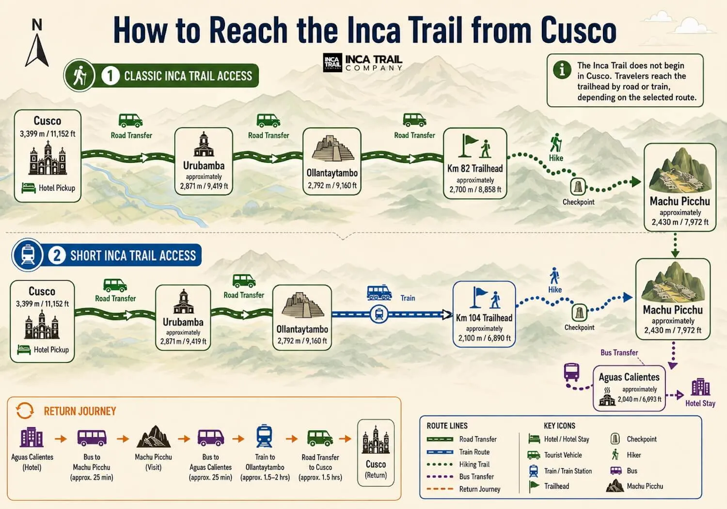
The Inca Trail does not begin in Cusco

Classic-route groups continue by road toward Km 82. Short-route travelers normally use the railway to reach Km 104.

Diagram showing access from Cusco through the Sacred Valley to the Km 82 and Km 104 Inca Trail starting points
Typical access sequence for the Classic and Short Inca Trail. Exact pickup, transfer and return arrangements depend on the selected operator.

Km 82 vs Km 104

Two trailheads, two different routes

The routes join near Wiñay Wayna, but their distance, elevation and earlier archaeological sequence are not the same.

FeatureKm 82Km 104
RouteClassic Inca TrailShort Inca Trail
Starting pointKm 82 · PiscacuchoKm 104 · near Chachabamba
Approx. hiking distance39 km / 24 mi to Inti Punku12–13 km / 7.5–8 mi
Typical formatMulti-day trekOne hiking day, often packaged over two days
Highest sectionDead Woman’s Pass · 4,215 mClimb toward Wiñay Wayna
Principal sitesLlactapata through Wiñay WaynaChachabamba and Wiñay Wayna
Final approachThrough Inti PunkuThrough Inti Punku
Classic route

Use the Km 82 map when researching the complete trail

It includes the principal mountain passes, long stone stairways and the fullest archaeological sequence. This is the geography most travelers mean by the traditional four-day Inca Trail.

Explore the Classic route
Short route

Km 104 joins the final historic approach

The trail climbs from Chachabamba toward Wiñay Wayna before continuing to Inti Punku. It does not cross Dead Woman’s Pass or the earlier mountain stages from Km 82.

Explore the Short route

How long is the Inca Trail?

The answer depends on the endpoint and measurement

For consistent geographic comparison, this guide uses approximately 39 km / 24 mi from Km 82 to Inti Punku.

Figures of 42–43 km / about 26 mi can include the final approach into Machu Picchu, campsite deviations or a different GPS track. The figures are not necessarily contradictory; they may describe different endpoints.

Classic to Inti Punku
≈39 km
24 miles
Extended measurements
≈42–43 km
about 26 miles
Short route
≈12–13 km
7.5–8 miles

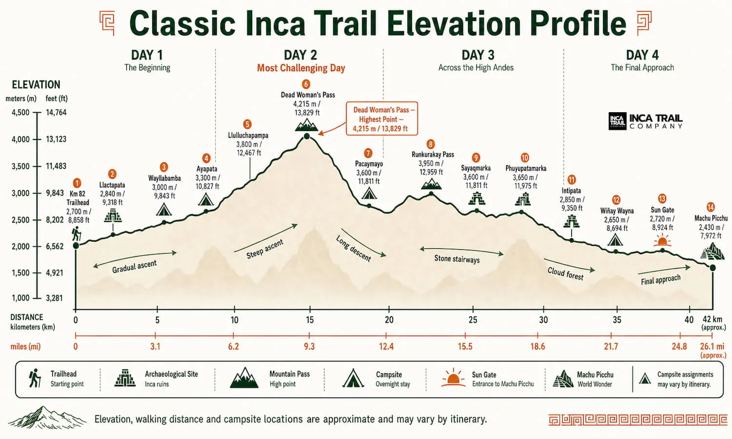
Elevation profile

One major climb, more passes, then a long descent

The moderate distance becomes physically serious because the route rises above 4,200 meters and repeatedly gains and loses elevation.

Classic Inca Trail elevation profile from Km 82 over Dead Woman’s Pass and down through Wiñay Wayna to the Sun Gate and Machu Picchu
Approximate Classic Inca Trail elevation profile. Campsite divisions can move between itineraries.

Highest point

Warmiwañusca, or Dead Woman’s Pass, reaches approximately 4,215 m / 13,829 ft and represents the largest sustained ascent.

Dead Woman’s Pass guide →

Changing environments

The route does not remain at maximum elevation. High mountain terrain gives way to long descents, cloud forest and the warmer landscape around Wiñay Wayna and Machu Picchu.

Follow the wildlife habitats →

Sites in trail order

A connected archaeological sequence

The Inca Trail is not simply a path to Machu Picchu. Its geography links settlements, terraces, water systems, ceremonial spaces and the final gateway.

Explore every site
  1. 01

    Llactapata

    Also written Llaqtapata or Patallacta, this is one of the first major sites visible after Km 82. Terraces and structures spread across the valley below the trail.

  2. 02

    Runkurakay

    A compact semicircular structure beside the trail in the high mountain section, often interpreted as a checkpoint, lookout or stopping place.

  3. 03

    Sayacmarca

    An elevated complex of narrow passages, stairways, stone enclosures and water channels overlooking the surrounding valleys.

  4. 04

    Phuyupatamarca

    The “Town Above the Clouds” contains terraces, buildings and water features near the point where the route begins its long cloud-forest descent.

  5. 05

    Intipata

    Extensive agricultural terraces built into a steep mountainside, demonstrating how the Incas adapted slopes for cultivation and land management.

  6. 06

    Wiñay Wayna

    The final major complex before Inti Punku, with steep terraces, stone buildings and a sophisticated water-channel system.

  7. 07

    Inti Punku

    The Sun Gate forms the historic approach to Machu Picchu and the defining transition from the mountain route to the final descent.

Geography by day

How the landscape normally unfolds

These are route summaries rather than a booking itinerary. Campsites and stopping points depend on allocation and operator planning.

Day 1

Km 82 and the lower valley

The trail begins at Piscacucho and follows comparatively open lower-valley terrain. This section introduces the original stone road and offers views toward Llactapata before elevation becomes more pronounced.

Km 82 · valley terrain · Llactapata
Day 2

The highest mountain crossing

The route climbs through increasingly high terrain to Dead Woman’s Pass, the highest point on the map, then descends sharply into the Pacaymayo valley.

Sustained ascent · 4,215 m · steep descent
Day 3

Passes, sites and cloud forest

A dense archaeological sequence accompanies additional elevated sections before the route loses height through long stone stairways and greener cloud forest toward Wiñay Wayna.

Runkurakay · Sayacmarca · Phuyupatamarca · Intipata
Day 4

The Sun Gate and Machu Picchu

The final mountain section reaches Inti Punku and then follows the descending approach toward Machu Picchu. This completes the route’s defining geographic sequence.

Wiñay Wayna · Inti Punku · Machu Picchu

The final approach

Sun Gate or Machu Picchu: where does the route end?

The precise geographic answer separates the two: Inti Punku is the mountain route’s ceremonial gateway, while Machu Picchu is reached after the descending approach.

Current visitor circuits, access points and re-entry conditions can change. Confirm the actual Machu Picchu admission and route included in a booking rather than interpreting this planning diagram as a current ticket instruction.

Understand permits and entry
Diagram of the final Inca Trail approach from Inti Punku down toward Machu Picchu
Illustrative final approach. Visitor flow and authorized circuits must be checked for the actual travel date.
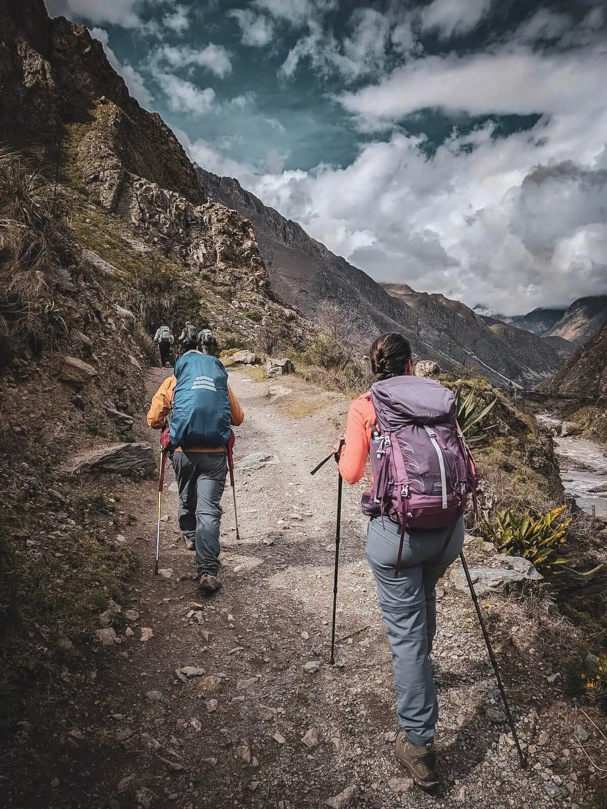
Hikers following a mountain section of the Classic Inca Trail

Map versus terrain

A short line on a map can contain hours of climbing

Distance alone cannot communicate stone stairways, altitude or the effort of repeating ascents and descents. Use the map for geography and the difficulty guide for physical preparation.

Read the difficulty guide

Quick answers

Inca Trail map FAQs

Distances remain approximate because endpoints, camps and measurement methods vary.

Where does the Inca Trail start?

The Classic Inca Trail starts at Km 82, known as Piscacucho, along the railway corridor between Ollantaytambo and Machu Picchu. The Short Inca Trail starts farther along the railway at Km 104.

Where does the Inca Trail end?

The route reaches Inti Punku, the Sun Gate, before descending toward Machu Picchu. Inti Punku is the historic gateway; Machu Picchu is the final destination.

How long is the Classic Inca Trail?

It is approximately 39 km or 24 miles from Km 82 to Inti Punku. Measurements of 42–43 km normally include additional approach sections, campsite variations or the final descent into Machu Picchu.

What does an Inca Trail map show?

A useful planning map shows the route, trailhead, high passes, archaeological sites, approximate camps, elevation changes, Inti Punku and Machu Picchu.

What is the difference between Km 82 and Km 104?

Km 82 begins the multi-day Classic route. Km 104 begins the Short route, which joins the final section near Wiñay Wayna and does not cross Dead Woman’s Pass.

How long is the Short Inca Trail?

The hiking route from Km 104 is commonly measured at approximately 12–13 km, or 7.5–8 miles, including Chachabamba, Wiñay Wayna and the approach through Inti Punku.

What is the highest point on the map?

Warmiwañusca, or Dead Woman’s Pass, is the highest point of the Classic route at approximately 4,215 meters or 13,829 feet.

Can this map be used for independent navigation?

No. The graphics are simplified planning references. Access is regulated and route operation, campsites and visitor flow can change.

Sources, methodology and map use

Our maps combine common route profiles, field imagery and official sanctuary context. They are designed to explain the route to travelers and tourism businesses, not to replace regulated access, a guide or current operating instructions.

Publishers and travel companies may cite the approximate figures when linking to this guide and preserving the endpoint and review-date context.

Reviewed August 5, 2026 · Corrections: contact our editorial team

From geography to planning

Check whether your route is available

A map shows where the trail goes. The live calendar shows whether permits remain for your intended route and date.

Check live availabilityExplore the Classic route